Kolašin 1450 piste map
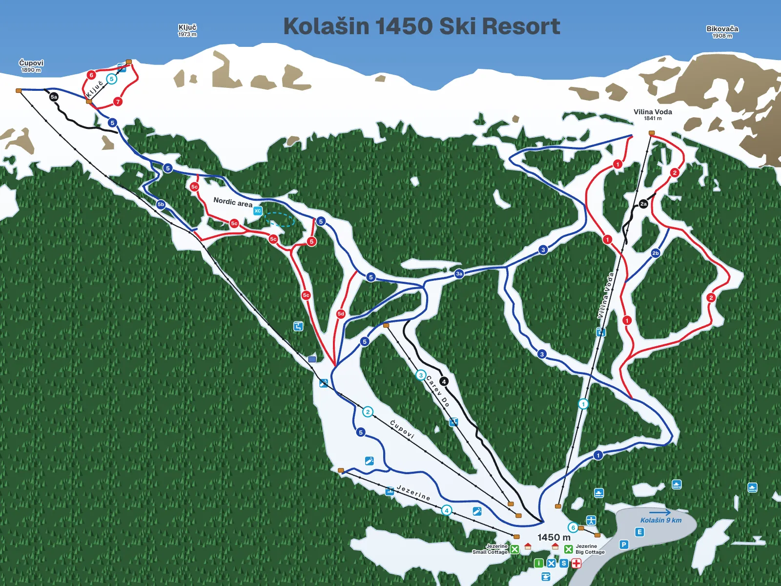
The Kolašin ski map for Kolašin 1450 on Bjelasica, above Kolašin: 6 lifts and 16 runs and variants, each with its number, name and level, redrawn after the operator's map. It does not show what is open today; for that, see the operator's conditions page and snow today.
Snow forecast
Snow and skiing today| Day | Base 1,450 m | Top 1,900 m |
|---|---|---|
| Today 22.11. | 4 / 5 °C24 mm · rain | 1 / 2 °C24 mm · sleet |
| Mon 23.11. | -7 / 5 °C21.2 mm · rain | -10 / 2 °C21.2 mm · sleet |
Sources
Model forecast, not a measurement; no snowfall in cm and no snow depth on the pistes.
Weather in Kolašin
How to read the map
The base is Jezerine at 1,450 m, bottom right on the map, with the entrance, car park, rental, ski school, first aid and the two Jezerine cottages beside it; an arrow points down the road to Kolašin, 9 km away. Two chairlifts start there: Vilina Voda (1), a six-seat to 1,841 m, and Ćupovi (2), a two-seat to 1,890 m at the left edge of the map. Three surface lifts fill the middle and the top: Carev Do (3) next to the black run of the same name, Jezerine (4) by the base and Ključ (5) under the highest labelled peak, Ključ (1,973 m); the baby lift (6) is at the base. The K7 Klisura chairlift to Kolašin 1600 also starts beside the base; it is drawn on the Kolašin 1600 piste map, not here.
Runs carry the operator's numbers and colours: blue for easy, red for intermediate, black for the steepest. A letter marks a variant of the same run (2a, 2b, 3a, 5a to 5d), and runs 1 and 5 each appear twice, once blue and once red. Blue tiles hold the lift symbols (chairlift, surface lift, baby lift), snowmaking points and services, green tiles the cottages, a red cross on white first aid, and the cyan tile the cross-country area. The labelled peaks are Ključ 1,973 m, Bikovača 1,908 m, Ćupovi 1,890 m and Vilina Voda 1,841 m.
Tap or click a run or lift to see its name, number and level in the panel. The filter above the map shows only lifts or only one colour, the Legend button lists every symbol, and the full-screen button enlarges the map, where the wheel or two fingers zoom and Esc closes it.
Lifts on the map
Runs on the map
Beginner area and the ski road
Beginners start at the base: the baby lift (6), 150 m long, and the Jezerine surface lift (4) are next to the entrance, and the resort has instructors who work with beginners; Ski-room 1450 at the base rents equipment. The nearest blue run is the lower Vilina Voda (1), which ends at the base; Bijela Lasica (3) winds down from the top of the Vilina Voda chairlift to join it, with 3a as a short branch and Vučji Kanjon 2b as the blue variant of run 2.
From the top of the Ćupovi chairlift the blue Ćupovi (5) is the long way home, with the Ski Put (5b), the ski road, running across the slope between the Ključ lift and the Jelenski Put. The reds from the same top are Jelenski Put (5c) and Propad (5d); the Ključ lift serves Ključ 1 (6) and Ključ 2 (7). The three blacks are Carev Do (4) beside its lift, Free Style (2a) off run 2 and Freestyle (5a) below the Ćupovi top. The K7 chairlift to Kolašin 1600 starts beside the base; each resort sells its own pass, so ask the Kolašin tourist information centre whether K7 is running.
Common questions
How many runs does Kolašin 1450 have?
Kolašin 1450 counts 12 pistes, 7 red, 2 blue and 3 black, between 1,450 and 1,900 m; the operator's map draws them as 16 runs and variants, 6 blue, 7 red and 3 black, because branches such as 2b, 3a and 5b have their own line.
Which runs at Kolašin 1450 are for beginners?
Beginners at Kolašin 1450 start on the baby lift (6) and the Jezerine surface lift (4) at the base, then take the blue runs: the lower Vilina Voda (1), Bijela Lasica (3 and 3a), Vučji Kanjon 2b, Ćupovi (5) and the Ski Put (5b).
Is there a black run at Kolašin 1450?
Yes, Kolašin 1450 has three black runs on the map: Carev Do (4) beside the Carev Do surface lift, Free Style (2a) off run 2 below the Vilina Voda chairlift, and Freestyle (5a) below the top of the Ćupovi chairlift.
Can you ski from Kolašin 1450 to Kolašin 1600?
Yes, when the K7 Klisura chairlift runs: it starts beside the Kolašin 1450 base and climbs to 1,778 m on the Kolašin 1600 side, but each resort sells its own pass, so ask the Kolašin tourist information centre whether K7 is running.
Does the map show which lifts are open?
No, the Kolašin 1450 map is a drawing of the layout; which lifts and runs are open is on the operator's weather and conditions page and its webcams at Jezerine (1,450 m) and Vilina Voda (1,841 m), and the snow today page shows the snow.
Where is the official Kolašin 1450 piste map?
The official Kolašin 1450 piste map is published by the operator on kolasin1450.com, whose web map is drawn on OpenSnowMap; the interactive map on this page is redrawn after the operator's printed map with every run and lift named.
Related
Sources
- Kolašin 1450, homepage and published piste map
- Kolašin 1450, lifts
- Kolašin 1450, piste map (OpenSnowMap)
- Kolašin 1450, weather and conditions
- Kolašin 1450, webcams
- Kolašin 1450 blog, top station heights (16 Apr 2021)
- Government of Montenegro, Information on ski areas (Oct 2014)
- Aktuelno (press, secondary): 2024/25 opening, lifts, pistes, Ski-room 1450 (26 Dec 2024)
- Government of Montenegro, K7 commissioning (14 Feb 2022)