


Need a car in Plav?
Rent a car for day trips and compare pick-up points in one search.
on Localrent
Photo: Андрей Романенко · CC BY-SA 4.0
Photo: Андрей Романенко · CC BY-SA 4.0
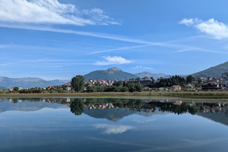
Plav is a small town at about 945 m in the far south-east of Montenegro, on the shore of Plav Lake where the Lim begins, with Prokletije rising above it and Albania and Kosovo across the mountains. The settlement had 4,121 residents in 2023 and the municipality 9,050. Most hiking tours into Prokletije start here; Hridsko jezero, one of the park's most visited sites, and the Gusinje side of the range with Ali Pasha's Springs and the Grebaje valley are within 20 km. From Podgorica it is 131 km, about 2 h 30 by car via Kolašin and Andrijevica.
| Elevation | about 945 m (average) |
| Population, 2023 | 4,121 in the settlement; 9,050 in the municipality |
| Municipality area | 326 km² |
| Basin | Plav-Gusinje basin, about 25 km long and 5 km wide |
| Plav Lake | 1.99 km², 906 m, 9.1 m deep; source of the Lim |
| National park | Prokletije, declared 2009, in the municipalities of Plav and Gusinje; 16,630 ha |
| Roads | M-9 from Kolašin via Andrijevica to Murino; R-9 from Murino to Gusinje |
Plav lies between the Prokletije ranges, the upper Lim and the Pećka Bistrica, with Berane to the north, Andrijevica to the north-west, Gusinje to the south-west, Albania to the south and south-east and Kosovo to the east. The town sits in the north-east of the Plav-Gusinje basin, the deepest and largest glacial landform of Prokletije, about 25 km long and 5 km wide and running north to south. The municipality has 14 settlements, with Plav as the main centre and Murino as the secondary one.

Five sights stand in and around the town:

From the town the views take in Plav Lake, Visitor and Prokletije. Plav Lake itself, the largest glacial lake in Montenegro at 1.99 km², lies directly below the town.
Plav is the quiet town where most Prokletije tours begin. The hiking season runs from June to the end of October, snow is possible even in summer, and the high routes call for a licensed guide. Prokletije National Park, declared in 2009 and lying in the municipalities of Plav and Gusinje, covers the mountains above the basin; entry is €3 per person per day, free under 15, and a park guide costs €40 for 4 hours or €80 for 8.
The walk on the Plav side is to Hridsko jezero, a glacial lake at 1,970 m inside a special nature reserve: 3.1 km on a linear trail, graded easy, about an hour. The stretch from Babino polje to the lake counts among the park's easy walks; Babino polje is 12.8 km, about 23 minutes by car from Plav. Three of the park's five mountain-bike routes are round trips from Plav, one each to Kofiljača, Memina planina and Hridsko jezero; the five routes together run 141 km. The Grebaje valley above Gusinje, the park's most visited part and the main starting point for mountaineering and climbing, is 19.6 km away. The Peaks of the Balkans trail has its own page.
The Plav fishing zone covers the Ljuča, Plav Lake and the first 4 km of the Lim, with grayling, brown trout, huchen, lake trout, pike, chub and nase. Plav Lake is closed to fishing from 1 October to 1 April, and huchen and pike are under a closed season in all waters until 1 April 2029. Winter brings snowshoeing on the Osmica trail near the town and skiing on open terrain; Plav has no lift-served ski centre.

Plav's calendar has the Lim Regatta, Blueberry Days, Behar Days and bicycle races; the dates are set each year.
Gusinje, 13.5 km and about 20 minutes south-west by the R-9, is the other town of the basin and a municipality in its own right again since February 2014, restored after a consultative referendum; it had been abolished in 1953. The settlement had 1,877 residents in 2023 and the municipality 3,933, on 157 km². Its landmarks are the Vizier's mosque (17th century), the Orthodox church of St George and, in Dolja 1 km from the town, the Catholic church of St Anthony. The summer festival, Gusinjsko ljeto, ran from 13 July to 5 August in 2025.
Ali Pasha's Springs (Ali-pašini izvori) belong to Gusinje municipality, not Plav: a group of karst springs at 925 m at the foot of Vezirova brada, described as the largest permanent karst spring in Montenegro. The water is very cold, the flow is strongest in spring, and it drains into the Vruja, which joins the Ljuča and reaches Plav Lake. From Gusinje it is 2.2 km by road, about 4 minutes; from Plav 15.4 km, about 25 minutes. Local belief holds that the water keeps you young and that marriages made here last; vows are often taken at the springs, once 30 weddings in a single day, and thousands gather here at the end of August. Other springs lie nearby, Savino oko, Bajrovića vrelo and Dragija, as does the 15 m Skakavica waterfall at the entrance to the Grlja canyon. The Grebaje valley is 7.2 km from Gusinje.
Private guesthouses and seasonal eco-katuns are mainly in the Grebaje valley, which also has two of the park's three mountain huts, Branko Kotlajić and Karanfil; the third, Hrid, is at Babino polje. Camping inside the national park is allowed only at designated paid pitches: €3 a day for a tent pitch, €20 for a serviced space.
The road in is the M-9 from Kolašin via Andrijevica to Murino, then on to Plav; the R-9 continues from Murino to Gusinje. From Podgorica it is 131 km, about 2 h 30, on the Smokovac-Mateševo motorway and then through Kolašin and Andrijevica. Berane is 41 km, Andrijevica 25 km and Gusinje 13.5 km. The railway at Bijelo Polje is 73 km away and the Port of Bar 232 km. Drive times ignore road works, snow and border queues.
Visits to the park run from May to October, with August the busiest month. The hiking season is June to the end of October, with snow possible in summer; the fishing season opens between 1 April and 15 May, depending on the snowmelt.
Plav is where most tours begin and is the start for Hridsko jezero and the park's bike routes; Gusinje is 13.5 km away and closer to Ali Pasha's Springs (2.2 km) and the Grebaje valley (7.2 km).
131 km, about 2 h 30, via the motorway to Mateševo, then Kolašin, Andrijevica and Murino.
141 km by road, about 2 h 45, via Kolašin and Andrijevica.
Rent a car for day trips and compare pick-up points in one search.
Postcode: postacg.me
Elevation: plav.me
Municipality area: monstat.org
Municipality population (2023 census): monstat.org
Nearest hospital: data.gov.me
Emergency medical service · Public
Health centre · Public
Hridska bb, Plav
hitna.me: Zavod za hitnu medicinsku pomoć: Organizaciona struktura (list of units) · Zavod za hitnu medicinsku pomoć: Kontakt (124 for all municipalities) · Zavod za hitnu medicinsku pomoć: Djelatnost zavoda (service 00-24, every day)
data.gov.me: Ministry of Health open data: Spisak svih zdravstvenih institucija u CG (xlsx, updated 2025-05-12)
gov.me: Government of Montenegro: Primary health care centres in Montenegro
fzocg.me: Health Insurance Fund: contracts with institutions in the health network
Town hall
Čaršijska bb, 84325 Plav
Municipality of Plav, About Plav (O Plavu), read 2026-10-16 · MONSTAT, 2023 census, population by municipality (Release 133/2024), read 2026-10-16 · MONSTAT, 2023 census, population by settlement and sex (xlsx), read 2026-10-16 · MONSTAT, Statistical Yearbook 2025, tables 1-2 (area), 1-6 (lakes), 1-9 (rivers), read 2026-10-16 · JPNPCG, Management Plan NP Prokletije 2026-2030 (PDF), read 2026-10-16 · JPNPCG, Prokletije, active holidays, read 2026-10-16 · JPNPCG, Prokletije price list, read 2026-10-16 · JPNPCG, Decision on fees (consolidated text), read 2026-10-14 · National Tourism Organisation, Prokletije National Park, read 2026-10-16 · National Tourism Organisation, Charming mountain towns (Plav, Gusinje), read 2026-10-16 · National Tourism Organisation, Hiking and trekking, read 2026-10-16 · National Tourism Organisation, Fly fishing (Plav zone), read 2026-10-14 · National Tourism Organisation, Snow sports (Osmica snowshoe trail), read 2026-10-15 · Tourist Organisation Gusinje, Ali-pašini izvori, read 2026-10-16 · Tourist Organisation Gusinje, Geographical position, read 2026-10-16 · Tourist Organisation Gusinje, home page (events), read 2026-10-16 · Tourist Organisation Gusinje, Valleys (Doline), read 2026-10-16 · Law on National Parks (Sl. list CG 28/2014, 39/16), Art. 16, read 2026-10-16 · OpenStreetMap node 778392894 Redžepagića kula, ODbL, read 2026-10-16 · OpenStreetMap way 420655007 Stara džamija, Plav, ODbL, read 2026-10-16 · OpenStreetMap node 4220097110 Ali-pašini izvori, ODbL, read 2026-10-16 · Routes computed with OSRM on OpenStreetMap data (ODbL) · Ministarstvo poljoprivrede, šumarstva i vodoprivrede, Naredba o ribolovnim zabranima, lovostaju i minimalnim veličinama riba (Sl. list CG 75/2026), Art. 3 · Municipality of Gusinje, Culture (Kultura), read 2026-11-01
Google Analytics counts visits without cookies. With your consent it also sets cookies that show us how the site is used. Nothing is used for advertising. Privacy