Need a car in Kolašin?
Rent a car for day trips and compare pick-up points in one search.
on Localrent
Photo: Ant83 at Serbian Wikipedia · Public domain
Mountain resort town
Northern Region · Mid-17th century (fortifications 1651)
Photo: Ant83 at Serbian Wikipedia · Public domain
Model forecast, not a measurement; no snowfall in cm and no snow depth on the pistes.
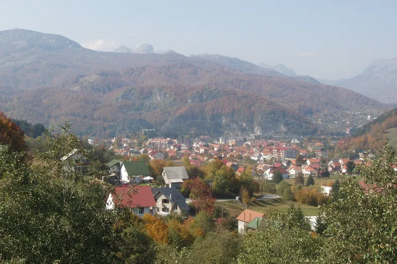
Kolašin is a mountain town at 954 m on the right bank of the Tara in northern Montenegro: 2,437 residents in the settlement and 6,700 in the municipality at the 2023 census. It lives in two seasons. In winter the Kolašin 1600 and Kolašin 1450 ski centres on Bjelasica, 9 to 12 km from the centre, are the biggest in the country; in summer the town is the base for Biogradska gora National Park and its primeval forest, 22 km away, and for the Bjelasica, Sinjajevina and Komovi trails. Podgorica Airport is about 80 km away, and the town has a station on the Bar-Belgrade railway, 1.5 km from the centre.
 Short Horseback riding - KolasinRating 5 (3)from €56.42
 NORTH TOUR Np Biograd Gora-Lake-Moraca Canyon & Monastery-KolasinRating 5 (3)from €160
 Jeep tour in National park Biogradska goraRating 5 (22)from €214.50
 Kolasin and Biogradska gora tourRating 5 (8)from €190
Tours, ratings and prices: Viator.
All tours in Kolašin
Two centres share Bjelasica above the town, and until the lift between them reopens each needs its own pass. Kolašin 1600, 12 km from town, is run by the state company Skijališta Crne Gore: the K8 six-seat chairlift rises to 2,035 m, with about 21 km of pistes on its own and about 45 km together with Kolašin 1450; two surface lifts were added for 2024/25. The K7 Klisura chairlift that links the two centres has been out of service since 2024. Lifts and restaurant work 09:00-19:00, parking costs €7 a day for a car, and a bus runs daily from the centre of Kolašin. A day pass costs €25 for adults and €16.50 for children.
Kolašin 1450 is the older, privately run centre with its base at Jezerine (1,450 m): a six-seat chairlift to Viline Vode (1,840 m), the two-seat Ćupovi chairlift and surface lifts, with about 26 km of runs. Its day pass costs €15 for adults and €12 for children, a season pass €400 and €250, with free weekday passes for residents of Kolašin, Berane, Andrijevica and Petnjica. Most beds are in town: hotels at the resorts are under construction, a shared garage for 626 cars is being built, and a gondola from Kolašin town to the two centres was announced for tender in January 2026. The 2025/26 season opened on 12-14 December 2025. Lift lists, piste counts and the full price tables are on the two resort pages.

The Ottomans built the town in the mid-17th century; its fortifications date from 1651. The Congress of Berlin made Kolašin part of Montenegro in 1878, the year the forests of Biogradska gora became the ruler's reserve, protected from felling ever since. From November 1943 to August 1944 Kolašin was the wartime capital of Montenegro, and ZAVNO, the country's anti-fascist assembly, was founded here in 1943.
| From | Distance | Note |
|---|---|---|
| Podgorica Airport | about 80 km | the nearest airport |
| Podgorica | about 75 km by the Morača canyon road, about 50 km via the Podgorica-Mateševo motorway | about an hour |
| Tivat Airport | about 154 km | via Podgorica |
By train, Kolašin is a stop on the Bar-Belgrade line, which climbs from 12 m above the sea at Podgorica to over 1,000 m here; the station is about 1.5 km from the centre. A second-class ticket costs €3.40 from Podgorica and €5.60 from Bar. The bus station is on Junaka Mojkovačke bitke street, and in winter ski buses run daily to the lifts.
The ski season runs from mid-December, when the lifts open for the season (12-14 December in 2025), into early April. Hiking on Bjelasica, Komovi and Sinjajevina is a June to October season; the park road to Biogradsko jezero stays open as long as it is clear of snow. Anglers find the park's stretch of the Tara fly-only and catch and release, and the Kolašin-Mojkovac reach catch and release all year. The weather page has the forecast and the snow report.

1600 is the larger, state-run centre with the six-seat chairlift to 2,035 m and a €25 day pass; 1450 is the older private centre with the cheaper day pass (€15). Until the K7 link reopens, each needs its own pass.
No. It is 22 km by road towards Mojkovac plus 4 km of park road; the lake loop itself is 3.5 km.
Yes, on the Bar-Belgrade line; the station is about 1.5 km from the centre and a second-class ticket costs €3.40.
Not on the World Heritage List. It is on Montenegro's tentative list (2010) and lies inside the Tara River Basin biosphere reserve.
Rent a car for day trips and compare pick-up points in one search.
Restaurant
Known for: kačamak, cicvara, river fish
Trebaljevo, put Kolašin-Mojkovac
Konoba (tavern)
Mateševo bb
Konoba (tavern)
Known for: kačamak, cicvara, trout, dishes under the sač
Trg Vukmana Kruščića
Restaurant
Known for: kačamak (the house speciality), veal under the sač
Sjerogoste bb
kolasin.me: TO Kolašin, Konak (restaurant page) · TO Kolašin, Konoba Amanet (restaurant page) · TO Kolašin, Kolašin on a plate: where to eat in the city under Bjelasica (11 Aug 2025) · TO Kolašin, Restoran Dobre Vode (restaurant page)
openstreetmap.org: OpenStreetMap node 1298477769 "Nišavić" (ODbL) · OpenStreetMap way 1176572234 "Dobre Vode" (ODbL)
Postcode: postacg.me
Elevation: montenegro.travel
Municipality area: monstat.org
Municipality population (2023 census): monstat.org
Train station: zicg.me
Nearest hospital: data.gov.me
Emergency medical service · Public
Health centre · Public
Dunje Đokić bb, Kolašin
hitna.me: Zavod za hitnu medicinsku pomoć: Organizaciona struktura (list of units) · Zavod za hitnu medicinsku pomoć: Kontakt (124 for all municipalities) · Zavod za hitnu medicinsku pomoć: Djelatnost zavoda (service 00-24, every day)
data.gov.me: Ministry of Health open data: Spisak svih zdravstvenih institucija u CG (xlsx, updated 2025-05-12)
gov.me: Government of Montenegro: Primary health care centres in Montenegro
fzocg.me: Health Insurance Fund: contracts with institutions in the health network
Town hall
Buda Tomovića bb, Kolašin
Tourist board office
opstinakolasin.me: Opština Kolašin: home page footer
data.gov.me: data.gov.me: Lista opština Crne Gore (Ministry of Public Administration, CC BY, updated 2025-05-30) · data.gov.me: Turističke organizacije (Ministry of Tourism, CC BY, updated 2025-09-30)
kolasin.me: TO Kolašin: home page header (kolasin.me)
MONSTAT, 2023 census, population by municipality (Release 133/2024) · MONSTAT, 2023 census, population by settlement · MONSTAT, Statistical Yearbook 2025, lakes, rivers and peaks · Tourist Organisation Kolašin, history · Tourist Organisation Kolašin, how to get to us · Tourist Organisation Kolašin, ski resort Kolašin 1450 · Tourist Organisation Kolašin, Biogradska gora · Tourist Organisation Kolašin, Biogradsko jezero loop (access) · Tourist Organisation Kolašin, Mount Bjelasica and trails · Tourist Organisation Kolašin, Vranjak-Crna glava trail · Tourist Organisation Kolašin, Mount Sinjavina · Tourist Organisation Kolašin, Mount Komovi · Tourist Organisation Kolašin, Moračke planine (Kapetanovo jezero) · Tourist Organisation Kolašin, canyons (Morača, Mrtvica) · Tourist Organisation Kolašin, churches and monasteries · National Parks of Montenegro, Management Plan NP Biogradska gora 2026-2030 · National Parks of Montenegro, Biogradska gora price list · National Parks of Montenegro, Biogradska gora active holidays · National Parks of Montenegro, Biogradska gora education page · National Tourism Organisation, Biogradska gora National Park · National Tourism Organisation, mountain towns · National Tourism Organisation, skiing · National Tourism Organisation, hiking and trekking · National Tourism Organisation, fly fishing · National Tourism Organisation, Podgorica (Kolašin distance) · Skijališta Crne Gore, Kolašin 1600 · Skijališta Crne Gore, parking price list · Skijališta Crne Gore, winter opening 2025/26 · Ministry of Tourism, answer to MP question on ski centres (2026) · Kolašin 1450, lifts · Kolašin 1450, ski pass 2025/2026 · Kolašin 1450, weather and station elevations · Biznis.rs, 30 Jan 2026, Kolašin gondola tender · Law on National Parks (Biogradska gora municipalities) · Wikipedia, list of World Heritage Sites in Montenegro (tentative list) · Wikipedia, Kolašin (coordinates) · ŽPCG, Red vožnje (timetable search with fares), Bar-Kolašin and Podgorica-Kolašin read for 16 October 2026 · Tourist Organisation Kolašin, Kanjon Mrtvica (hiking trail page) · Skijališta Crne Gore, ski pass price list 2025/26
Google Analytics counts visits without cookies. With your consent it also sets cookies that show us how the site is used. Nothing is used for advertising. Privacy