Šavnik
Town of three rivers and two dawns, the base for the Nevidio canyon
Northern Region · 360 people (settlement) · est. 1861
Raining now · 5 °CPhoto: Andrija12345678 · CC BY-SA 4.0
About Šavnik
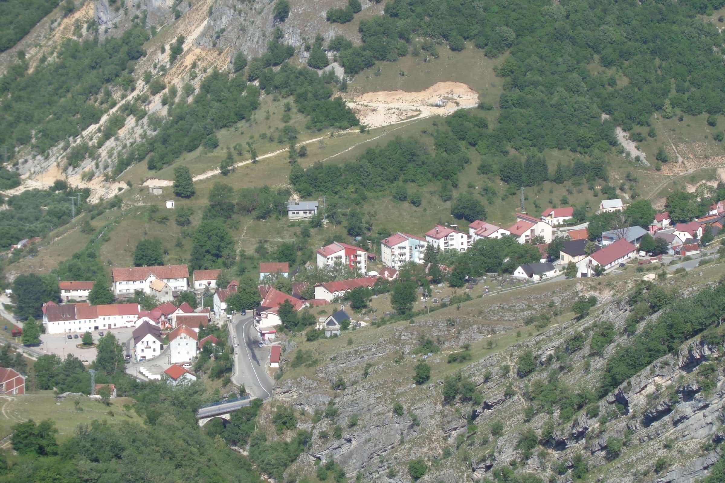
Šavnik is the seat of Montenegro's smallest municipality: a town of 360 people at 840 m where three rivers, the Bijela, the Bukovica and the short Šavnik, meet below Durmitor. The municipality has 1,569 residents (2023 census) on 556 km², over 90% of it above 1,000 m. Visitors stop for the Nevidio canyon, 5 km away, for the monasteries and old houses of the Drobnjak villages, and because the town lies on the all-year road from Nikšić to Žabljak, 26.5 km away. Half a day is enough for the town itself; Nevidio is a guided day out.
Getting there
Šavnik lies on the road between Nikšić and Žabljak, the way to Durmitor when the road over the Sedlo pass from Plužine is closed by snow; a regional road leaves for Boan and Kolašin over the Moračke planine. There is no railway (the nearest stations are Nikšić and Kolašin), and no bus timetable for Šavnik is published; the buses guide explains how to find a line. Snow can fall from November, so check the road conditions in the cold months. Distances by car from the town, without traffic:
| To | Distance | Driving time |
|---|---|---|
| Nevidio meeting point | 5.0 km | about 8 min |
| Boan | 15.8 km | about 18 min |
| Sedlo pass | 26.3 km | about 32 min |
| Žabljak | 26.5 km | about 32 min |
| Black Lake | 29.2 km | about 36 min |
| Piva Monastery | 43.8 km | about 1 h 05 |
| Nikšić | 47.4 km | about 1 h 10 |
| Đurđevića Tara bridge | 48.3 km | about 1 h 02 |
| Plužine | 61.0 km | about 1 h 13 |
| Kolašin | 73.3 km | about 1 h 28 |
| Podgorica | 98.0 km | about 2 h 09 |
| Podgorica Airport | 106.4 km | about 2 h 22 |
| Tivat Airport | 129.7 km | about 2 h 53 |
Three rivers and two dawns
The three rivers meet at the end of the town, and below it their water flows on with the Komarnica to Piva Lake. The Šavnik runs only about 1 km from its karst spring, Glava Šavnika; the Bijela, 17 km long, rises below Lola near Gornja Bijela and passes through a 1.5 km canyon just above the town; the Bukovica, over 40 km long from its source at 1,350 m near the Ivica tunnel, cuts a 9 km canyon down to it. All three hold brown trout, best fished in May, June, September and October; see Bukovica and Tušina and the fly-fishing page for the closed seasons.

Šavnik is known locally as the town of two dawns: around the equinox the sun rises behind the hill Kravica, sets behind Gradac at about 14:00, comes out again over the Bukovica canyon and sets a second time behind Vojnik. Five mountains frame the municipality: Durmitor to the north, Sinjajevina to the north-east, the Moračke planine to the east, the Krnovo plateau to the south and Vojnik, with 48 summits above 1,500 m and Veliki Vojnik at 1,998 m, to the south-west.
Nevidio and the nature park
The meeting point for the Nevidio canyon on the Komarnica is 5 km from town, about 8 minutes by car. First passed in 1965 by the Javorak mountaineering club, the canyon takes 3 to 4 hours for about 2 km and is done only with full equipment and a trained guide, from mid-June to the end of September. The same goes for the Grabovica canyon nearby, about 1 km long and sunlit for most of its length, with abseils through waterfalls and pools. Other canyons are on the canyoning page.
Nevidio lies in the Dragišnica i Komarnica nature park, 2,994 ha between 650 and 1,998 m on the border of Durmitor National Park, with more than 1,000 plant taxa and 64 bird species recorded. The park also takes in Boljske grede, a cliff band almost 3.5 km long with walls up to 700 m and a top at 2,091 m. On the Grabovica, the Skakavica waterfall, about 70 m high, runs in snowmelt and heavy rain, freezes in winter and draws ice climbers.
Monasteries and houses of Drobnjak
Podmalinsko Monastery (St Archangel Michael), on the right bank of the Bukovica, dates from about 1252 and was restored in 1908 and again in 2002 for its 750th year; Drobnjak's first school opened in its lodgings in 1870. Bijela Monastery (St George), about 8 km from town in the village of Bijela, is dated to the 11th century in some accounts and to the 17th in others; it burned in 1702 and 1840, was restored in 1705-1735 and rebuilt in full in 1887. See also churches and monasteries.

In Tušina the family house of Novica Cerović (1805-1895), vojvoda, senator and the only ban of Montenegro, keeps his room with its furniture; his father built it in the early 19th century and a tufa upper floor was added later. Memorials stand at Petnjica, the village the family of Vuk Stefanović Karadžić came from, and at Mljetičak, where the Ottoman commander Smail-aga Čengić was killed on 5 October 1840. In Šavnik itself the family house of the writer Borislav Pekić has been restored as a residence for artists and a venue for cultural events. More than a hundred stećci, medieval tombstones, survive at Gornja Bijela, where they were reused in a church foundation, at Pošćenje, around and in the walls of the church, and at other sites; the UNESCO-listed stećci are in Žabljak and Plužine municipalities. Pošćenje also has two glacial lakes about 300 m apart.
History in brief
The area appears as the župa Komarnica in the 12th-century Chronicle of the Priest of Duklja and as the nahija Komarnica in an Ottoman register of 1477; the name Drobnjak is recorded from 1285. Part of the Nemanjić state from the second half of the 12th century, later under King Tvrtko and Herceg Stjepan, it fell to the Ottomans around 1470 and was united with Montenegro in 1858, recognised in 1878, after which Drobnjak was split into three captaincies seated at Šavnik, Boan and Žabljak. Drobnjak is known for its gusle players.
The town dates from 1861, when pop Luka Đurović from Bjelopavlići and Rade Šujov Karadžić repaired the Petnjica mill, opened an inn and shop and built a house where the Šavnik flows into the Bukovica; the first three buildings were the inn with its shop, a gunsmith's and a blacksmith's. Its name comes from šavice, willow withies once used for roofing. After 1918 Šavnik became the administrative centre of the whole Durmitor area, and brides from Risan brought builders with them, which gave the houses a touch of the coast. It was a district seat in 1918-1941 and 1944-1948, when the seat moved to Žabljak, and the present municipality dates from 1952. Municipality Day, 22 July, marks the 1941 attack on the occupation command that freed the town. The municipality had 7,512 people in 1948, 2,974 in 2003 and 1,569 in 2023.

Practical information and seasons
The health station, part of the Nikšić health centre, is the only health facility in the municipality, with field clinics at Bukovica and Boan; there is no emergency unit in town, and emergency calls to 124 are answered from neighbouring towns. The nearest general hospital is in Nikšić, 47 km away. The town has a Montefarm pharmacy, a Prva banka counter and ATM, a post office (81450; Gornja Bukovica 81453, Boan 81455) and a Jugopetrol station. Accommodation is small: a rebuilt hotel, eco-villages, cottages and apartments, and mountaineering camps in the villages.
Winters are long and snowy and summers short: the mean annual temperature in town is 8 °C, with up to 210 sunny days and about 2,023 mm of precipitation a year, and snow can come in November. Canyoning runs from mid-June to the end of September and trout fishing is best in May, June, September and October. In winter the town is the way through to Žabljak when Sedlo is shut, and the Skakavica falls freeze for ice climbing.
Nearby
- Žabljak, 26.5 km: Black Lake, the Bobotov kuk trailheads and the Žabljak in 3 days plan.
- Plužine and Piva Monastery, 44-61 km, on the far side of Durmitor.
- The Đurđevića Tara bridge on the Tara, 48 km.
- Kolašin, 73 km over the Moračke planine and Boan.
- The northern Montenegro page sets Šavnik beside the other Durmitor towns; the 7-day and 10-day loops use the Nikšić-Šavnik-Žabljak road.
Questions
How far is Šavnik from Žabljak?
26.5 km, about 32 minutes by car. When the Sedlo road is closed in winter, this is the way from Nikšić to Žabljak.
How do I get to Nevidio from Šavnik?
The meeting point on the Komarnica is 5 km from town, about 8 minutes by car. The canyon is passed only with a guide and full equipment, from mid-June to the end of September; details on the Nevidio page.
Why is Šavnik called the town of two dawns?
Around the equinox the sun sets behind Gradac at about 14:00, then appears again over the Bukovica canyon before it sets a second time behind Vojnik.
How high is Šavnik and how many people live there?
The town lies at 840 m. The 2023 census counted 360 people in the town and 1,569 in the municipality, the smallest in Montenegro.
Where does the name come from?
From šavice, the willow withies once used for roofing. The town was founded in 1861 around an inn at the mouth of the Šavnik river.
Is there a hospital in Šavnik?
No. The health station belongs to the Nikšić health centre, and the nearest general hospital is in Nikšić, 47 km away.
Local cuisine
Town facts
- Postcode
- 81450
- Elevation
- 840 m
- Municipality area
- 556 km²
- Municipality population (2023 census)
- 1,569
Sources
Postcode: postacg.me
Elevation: savnik.me
Municipality area: monstat.org
Municipality population (2023 census): monstat.org
Bus, parking, services
Nearest hospital
- Opšta bolnica Nikšić
- Nikca od Rovina bb, Nikšić
- +382 40 231 204
- 68 min by car (46.3 km)
Sources
Nearest hospital: data.gov.me
Health
Zdravstvena stanica Šavnik
Health centre · Public
Šavnik bb, Šavnik
Town hall and tourist information
Opština Šavnik
Town hall
81450 Šavnik
Turistička organizacija Šavnik
Tourist board office
Šavnička I 18C, Šavnik
Sources
MONSTAT, 2023 census, first results: population by municipality (release, EN) · MONSTAT, 2023 census, population by settlement and sex (xlsx), read 2026-11-01 · MONSTAT, Statistical Yearbook 2025, table 1-2 (area of municipalities) · Municipality of Šavnik, geographic position (840 m, rivers, surrounding mountains), read 2026-11-01 · Municipality of Šavnik, history and cultural heritage, read 2026-11-01 · Municipality of Šavnik, territory and population (1948-2011 trend), read 2026-11-01 · Municipality of Šavnik, climate, read 2026-11-01 · Municipality of Šavnik, health institutions, read 2026-11-01 · Municipality of Šavnik, tourism (fishing, brown trout, accommodation), read 2026-11-01 · Municipality of Šavnik, Park prirode Dragišnica i Komarnica, read 2026-11-01 · Municipality of Šavnik, about Šavnik (schools: first school in Podmalinsko, 1870), read 2026-11-01 · TO Šavnik, history (Drobnjak, 22 July 1941), read 2026-11-01 · TO Šavnik, origin of the town (1861, name), read 2026-11-01 · TO Šavnik, special features of Šavnik, read 2026-11-01 · TO Šavnik, town on three rivers, read 2026-11-01 · TO Šavnik, the town where the sun rises twice, read 2026-11-01 · TO Šavnik, river Šavnik, read 2026-11-01 · TO Šavnik, river Bijela, read 2026-11-01 · TO Šavnik, river Bukovica, read 2026-11-01 · TO Šavnik, canyoning (Nevidio, Grabovica), read 2026-11-01 · National Tourism Organisation, canyoning (season, Nevidio) · TO Šavnik, nature park Dragišnica i Komarnica, read 2026-11-01 · TO Šavnik, Boljske grede, read 2026-11-01 · TO Šavnik, Vojnik, read 2026-11-01 · TO Šavnik, Skakavica waterfall, read 2026-11-01 · TO Šavnik, Pošćenje lakes, read 2026-11-01 · TO Šavnik, Podmalinsko Monastery, read 2026-11-01 · TO Šavnik, Monastery of St George, Bijela, read 2026-11-01 · National Tourism Organisation, mountain towns (Šavnik: Bijela Monastery, two dawns) · TO Šavnik, house of Novica Cerović, read 2026-11-01 · TO Šavnik, house of Borislav Pekić, read 2026-11-01 · TO Šavnik, Vukovi korijeni memorial, Petnjica, read 2026-11-01 · TO Šavnik, memorial to Smail-aga Čengić, Mljetičak, read 2026-11-01 · TO Šavnik, stećci, read 2026-11-01 · UNESCO World Heritage Centre, Stećci Medieval Tombstone Graveyards (1504), components · Nature Park Piva, 19 Apr 2025, Plužine-Žabljak road over Sedlo reopened after the winter closure · ŽPCG, timetable (stations Nikšić and Kolašin) · National Tourism Organisation, fly fishing (Šavnik zone, best months) · Institute for Emergency Medical Aid, organisational structure (emergency units) · Health Insurance Fund of Montenegro, health institutions in the network (general hospitals) · Ministry of Health open data, health centres and clinics (Zdravstvena stanica Šavnik) · Montefarm, pharmacies · Prva banka Crne Gore, branch network · Pošta Crne Gore, post office 81450 Šavnik, read 2026-10-15 · Jugopetrol, station finder · OpenStreetMap way 173535433 Šavnik (place), ODbL · Routes computed with OSRM on OpenStreetMap data (ODbL), queried 2026-11-01